The most frequent request we receive from users is to provide precise information about the location and timing of a significant seismic event (M5+ “Greater than 5 Richter”), which could be dangerous for people, property, and animals in the near future in Italy.
The EqForecast seismic prediction model (Pre-Seismic Alert Service – SAP) can provide this information both in real time and in the medium term, utilizing astronomical parameters it routinely references.
SAP aligns with the first (OEF) of the three informational systems outlined in the recent Horizon2020 project by the EU (though SAP is not currently part of it), which includes Operational Earthquake Forecasting (OEF), Earthquake Early Warning (EEW), and Rapid Earthquake Response (RRE).
Operational Features of the SAP Service
Real-Time Seismic Forecasts
- SAP sends real-time pre-seismic alerts to subscribed users up to 19 hours before the predicted earthquake. Users can choose the magnitude and locations for which they wish to receive pre-alerts.
- The real-time pre-seismic alert identifies three dimensions of risk: estimated maximum magnitude, locations within a 30/60 km radius (user-selected), and the time window of the potential epicenter, always starting up to 19 hours before the predicted earthquake.
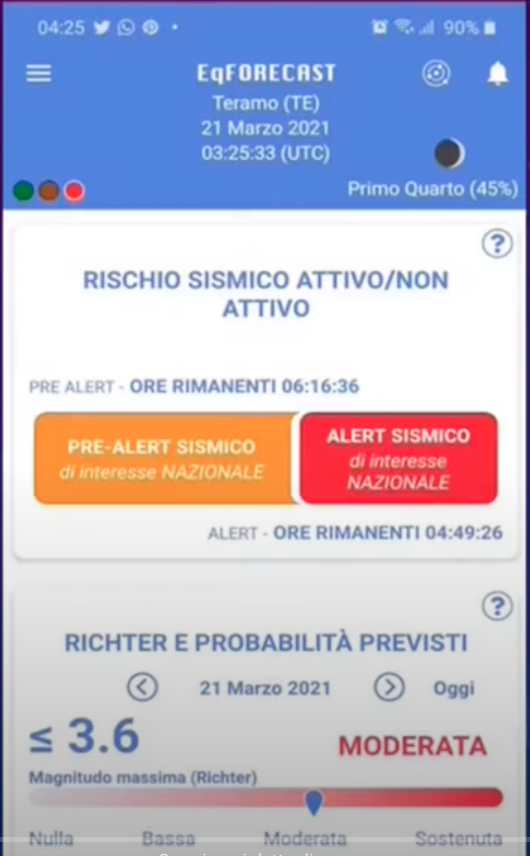
Subscribed users of the EqForecast app receive an audible notification on their phone from a few hours to a few minutes before the quake if their selected locations are at seismic risk, indicating the expected maximum magnitude and the seismic risk time.
For earthquakes > M4, the pre-seismic alert notification arrives via the EqForecast App for iOS and Android from a few hours to a few minutes before the potential event. If the selected location is at seismic risk, the user will see the location on the app’s home screen—both as text and as a point on the “User View” map—with a red traffic light signal at the top left of the app’s home screen.
Short-Term Seismic Forecasts (6 hours)
The map of locations at seismic risk for the next 6 hours, indicated by a red dot, is available on the home screen of the EqForecast app’s SAP Service. This is the “national view” map found on the app’s home page, available for PRO subscribers.


See here a useful explanatory video (subtitles EN) on the seismic forecast map for the next 6 hours.
Medium-Term Seismic Forecasts
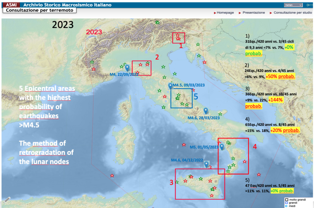
The Medium-Term SAP allows for the construction of annual epicentral maps of seismic risk M5+ and theoretical long-term astronomical risk calendars. The model for constructing seismic risk maps for future years is based on the precession of lunar nodes, see DOI: 10.13140/RG.2.2.16867.02088.
For example, as of May 13, 2023, 4 out of 5 earthquakes ≥M4.5 had epicenters within or near one of the 5 areas identified using the astronomical model of lunar node precession. Only area 5 was added after the March 9, 2023, earthquake, simply because it had been omitted. However, historical green stars (earthquakes from 1600-1899) and red stars (earthquakes from 1900-2022) indicating past earthquakes occurring in 9.3-year cycles from 1600 to the present were present in good concentration. The blue area 5 remains one of the least probable compared to the average of previous years for a significant earthquake in 2023: probability +0% compared to the average of the 9.3-year cyclical periodicity backward in time to 1600.
 Deepening:
Il rischio sismico teorico astronomico (ATR), clicca QUI.
EqForecast’s Pre-seismic Alert Mechanism
False alerts
From these brief outlines it is therefore clear that the pre-earthquake alert of the SAP materialises in one or more alerts to users (short term) or in a calendar and maps of days and places at seismic risk (medium term) in a non-unique manner (‘dry forecast’), but with multiple alerts over time.
In effect, a false alert rate of less than 3% of the time for earthquakes greater than M5 is realised for each citizen over their lifetime. This means, for example, that based on the experimental evidence, in one year each SAP user can be alerted for M5+ earthquakes from 0 to 11 total days/year, with an error % (missed alert) <15%.
Alerts for earthquakes at sea and volcanic eruptions.
The pre-seismic alert does not work with certainty for coastal or at-sea earthquakes, nor for earthquakes connected to volcanic eruptions. This is due to the fact that the INGV seismograph, for obvious economic and technical reasons, does not have an extensive network of seismographs at sea: we have already discussed this in the article opposite.
The SAP sends the pre-seismic alert by identifying the three dimensions of the risk: maximum magnitude, location within a radius of 30 km and time zone of the potential epicentre, starting 19 hours before the expected earthquake.
The estimated magnitude and location of the seismic alert in real time.
Other algorithms calculate WHAT estimated maximum MAGNITUDE we are talking about, based on statistical parameters of other past earthquakes that occurred in the presence of similar astronomical positions of the S.S. planets, the Sun and the Moon, now and then.
Other georeferenced statistical algorithms, on the other hand, tell us WHERE the next earthquake will be triggered, based on past seismicity in the presence of similar astronomical positions of the S.S. planets, the Sun and the Moon, today as then.
The real seismic risk (ARR) provided by an INGV seismograph sequence
If the INGV seismograph gives us the ‘known sequence’ (currently reserved for EqForecast insiders ed.) of a few low-magnitude earthquakes in succession in those hours when we have the astronomical alert identified by the Timeline, this is a sign that a fault(s) is/are moving. Then, the EqForecast robot calculates the compatibility of the “signal” coming from the ground with the presence of concomitant geographical and thunderstorm pre-alerts, calculated by our algorithms as specified above. We speak in this case of the astronomical real risk component – ARR of the pre-seismic alert.
When the theoretical astronomical ATR component of the EqFoecast model and the real ARR component of the INGV seismograph go into temporal/geographical resonance, then the App will send an alert notification to users, for areas where there is “movement” in those minutes.